


Pinpointing the Past
Many visitors may recall seeing the Nicholas and Jan Martense Schenck homes on display, as part of the Brooklyn Museum’s period room collection. These two houses, along with additional primary sources, provide a fascinating window into the life of the Schenck family and other early Brooklyn settlers.
Brooklyn Museum Archives. Lantern Slide Collection. Nicholas Schenck Homestead.
While we are fortunate for the Schenck households to have survived, they are the exception to the rule. Many of the colonial homesteads were razed around the turn the 20th century, providing needed space for a rapidly growing city. Although lost, we have glimpses of how they looked thanks to the documentary works of late 19th century photographers. Many such photographs are housed in the Museum’s Libraries and Archives and are currently being digitized as a facet of the CHART Project.
As a project CHART intern, one of my roles is to provide context to these photographs through research. Leveraging resources in the Museum’s Libraries and Archives, as well as those at project CHART partner institutions we can uncover a great deal. For buildings, such as colonial homesteads, one important fact we try to discover is location. But how do you locate a house demolished over a hundred years ago? Fortunately, recent digitization projects have made vast historical knowledge only a few mouse clicks away. The Brooklyn Public Library’s Daily Eagle newspaper archive is one such resource we use, providing insight into daily Brooklyn life around the turn of the century.
.jpg)
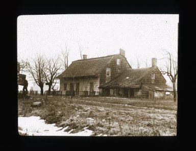
Brooklyn Museum Archives. Lantern Slide Collection.Simon Cortelyou House House at Ft. Hamilton.
For example, Cortelyou is a well-known family name in Brooklyn history. We have a number of images of homes owned by members of the Cortelyou family including the Simon Cortelyou homestead, but where exactly did it stand? Using the Daily Eagle archive I found references to the Cortelyou house in an article about the expansion of Fort Hamilton. The paper details that the 1668 homestead was located on the bluff of Gravesend Bay near Denyse ferry, which gets us closer but still not perfect.
.jpg)
Brooklyn Public Library. Brooklyn Collection. Daily Eagle clipping, October 10, 1901.
What we need is a map, from the late 1800’s no less. Fortunately, the New York Public Library has a project to digitize historical maps and make them available online. Browsing their archive I located a map of the area of interest from 1890. Zooming in on Fort Hamilton we discover a hand written note locating the old Cortelyou homestead! This map had been recitfied, meaning it has been geographically matched with a modern map, allowing us to know the exact location where the house used to stand.
.jpg)
New York Public Library. Map Division. Robinson's Atlas of Kings County, 1890.
Utilizing such resources we are able to strongly link the past with the present. In doing so we better understand the rich cultural heritage of our city, and can place ourselves within its history.
By Matthew Miller - Brooklyn Museum intern